Spending a Day in Canyonlands National Park
Spending a Day in Canyonlands National Park
Canyonlands National Park is a huge park with 337,598 acres of canyons, buttes, and desert to explore. So what do you do if you only have one day to visit the park? We visited Canyonlands in mid-December and unfortunately we only had one day to spend in the park, because we were headed across the country to spend time with our families for Christmas.
Canyonlands National Park has four districts. The Island in the Sky district is the most developed and most visited part of the park. The Needles district is less visited and less accessible than Island in the Sky, although parts of The Needles are still accessible with a two-wheel drive vehicle. The Maze district can only be accessed by skilled drivers with high clearance, low-geared vehicles. It’s extremely remote. These three districts are separated by the Green and the Colorado Rivers. The Horseshoe Canyon Unit is a smaller day use area with Native American rock art. Although the districts are close as the crow flies, by road the park’s district are actually between two to six hours apart.

The landscape of Canyonlands will have you questioning whether you are on Earth or on Mars.

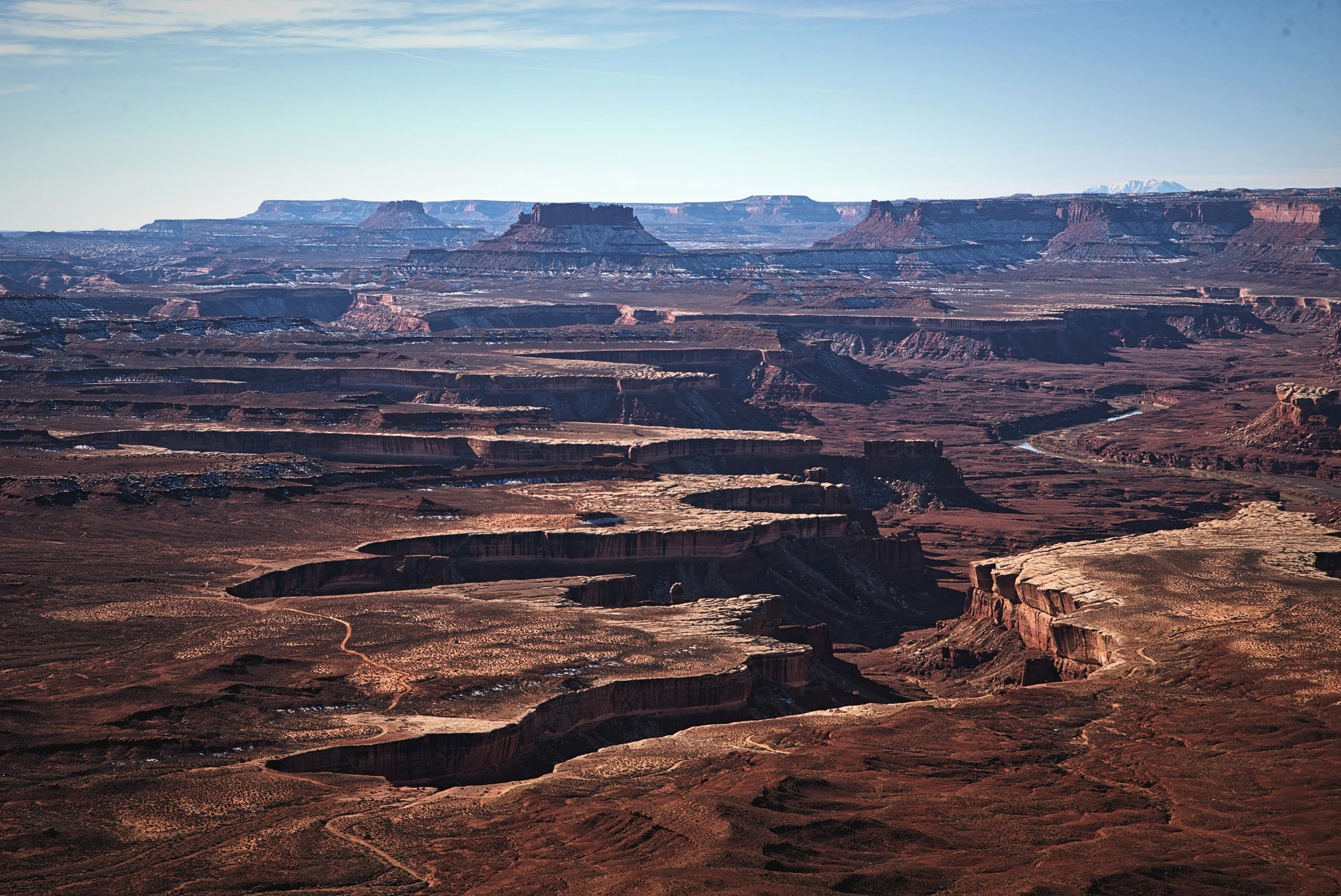
Ian looks out over the incredible tablelands of Island in the Sky.
If you only have one day to visit Canyonlands National Park, Island in the Sky is probably the best and easiest district to visit. It offers plenty of short hikes and viewpoints without having to venture off road or into the backcountry. Plus it’s only about 30 minutes from Arches National Park and Moab. Here’s how we spent one day in beautiful Island in the Sky!
Sunrise at Mesa Arch
We started our day in this impressive national park early—at 5:45am. It was mid-December so it really chilly when we woke up. We made some coffee to help us warm up, and headed into the park from our free campsite just outside the park (see our Canyonlands free camping recommendations at the bottom of this blog post). We woke up so early in order to watch the sunrise at Mesa Arch, which might just be one of the most famous places in the country to watch the sunrise.

The gentle glow on the horizon before sunrise in Canyonlands.

Arrive at Mesa Arch before sunrise so you can get set up and see the light change.
It was getting a bit light as we drove into the park. We’ve noticed that the best colors of the sunrise often occur well before the sun rises above the horizon, we were a bit worried that we were going to miss the most colorful part of the sunrise. Fortunately since it was December the sun didn’t rise until 7:28, so we didn’t miss anything.
When we arrived, we hopped out of the van and quickly walked up the quarter mile trail to Mesa Arch with our camera gear and coffee. When we arrived at the arch, the sky was the deep blue of dawn, gradually transitioning to yellow. We were wrapped up in our winter sleeping quilt. It was 20 degrees, which was much warmer than when we watched the sunrise at Sunrise Point a few days earlier in Bryce Canyon National Park (check our photos of that sunrise in our blog post “How to Enjoy Bryce Canyon in Winter.”)

When we were at Mesa Arch there was only one other person with a tripod photographing the sunrise.

In summer there’s sometimes 50 people trying to photograph the sunrise at Mesa Arch. Winter is a different story.

The light at daybreak at Mesa Arch is unbelievably beautiful.
Fortunately for us, most people thought that 20 degrees was too chilly for watching the sunrise. When we arrived, there was only one other guy there photographing sunrise, which is really unusual. In summer, there are sometimes a group of 50 people attempting to photograph the arch at sunrise. Right before sunrise, a few other people trickled up to the arch, but no one else with a camera and tripod. So we basically had a clear view to photograph the arch.

One of my favorite moments is when the sun comes above the horizon and you can see the Earth visibly rotating.
Mesa Arch is such a famous spot for watching and photographing sunrise because when the sun breaches the horizon, it turns the entire underside of the arch a brilliant red color. Behind the arch, the sun illuminates a colorful vista of Canyonlands National Park. Beyond that you can even see the La Sal Mountains in the distance.
Mesa Arch itself is low and wide. It’s not a very tall arch, but it spans a fair distance. The arch is right on the edge of a sheer, vertical cliff. You can walk to the edge, but be careful! If you were to fall it would be 500 feet to the floor of Buck Canyon.

The shadows on the rock of Buck Canyon at dawn are beautiful.

If you’re planning to photograph Mesa Arch, walk around and try a few different compositions.
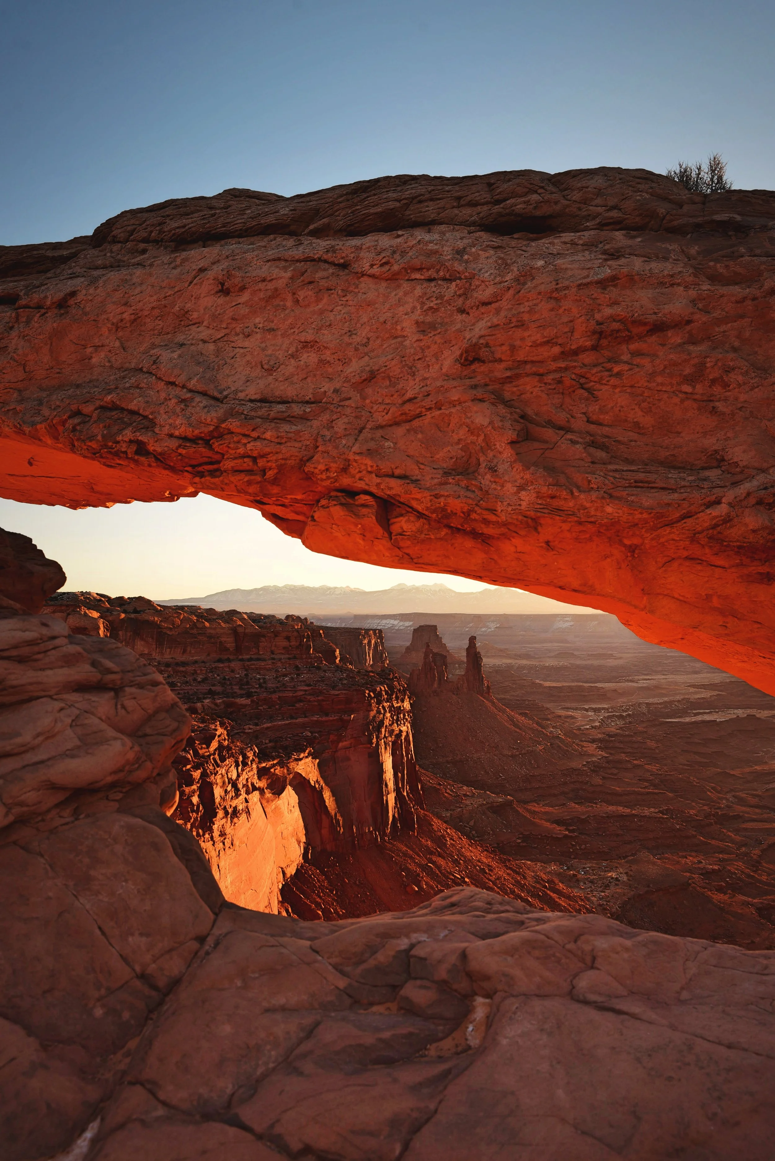
The sunrise turns the underside of Mesa Arch a beautiful red color.
As the sun crept closer to the horizon, the sandstone all around us started to warm to a golden color. It’s not until the moment the sun comes over the horizon that the bottom of the arch transforms to a rosy red. The arch’s opening faces eastward, so the arch frames the sunrise. The higher the sun got, the more the arch and the canyon below it lit up. In our opinion some of the best light was a bit after sunrise when there was more light in Buck Canyon below.
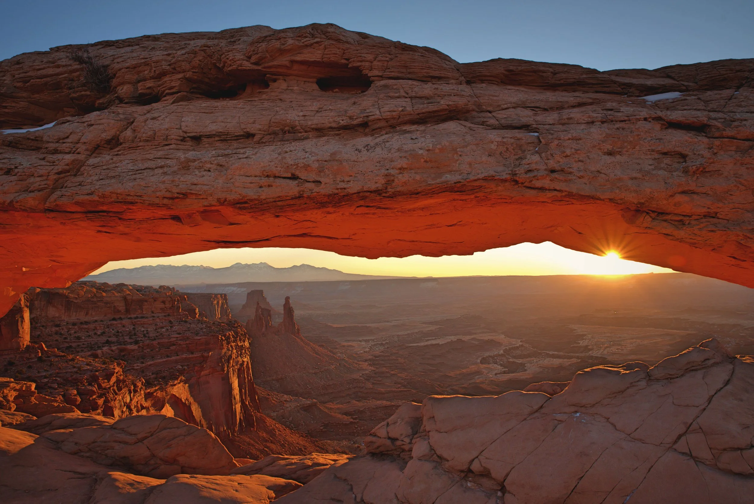
When the sun is a bit higher above the horizon, more of Buck Canyon below is illuminated.
Mesa Arch is “Insta-famous” and it was even a stock desktop background for Windows 7. Sometimes when we’ve visited iconic landscapes like this, we’ve been a bit underwhelmed by the reality vs. the photos. Mesa Arch is not one of those places. I think Mesa Arch might be one of the best places in the nation to watch the sunrise—especially in winter when there aren’t a million other people with the same idea.
Grand View Point
After eating a post-sunrise breakfast in the van, we drove the 6 miles to the end of the south branch of the park road to Grand View Point. The view from the Grand View Point is really indescribable. Island in the Sky earns its name, because the district is a high mesa with sheer cliffs, surrounded by a canyon which in some places is 1000 feet below. You’re on the top of the mesa and looking down onto a flat benchland, and cutting through the benchlands are the rugged, deep canyons. They are huge, indescribable cracks in the earth stretching into the distance. Spires of orange layered sandstone rim the canyons’ walls.
A 100-foot paved trail leads you to this vista. From there, you have the option of doing a two mile round-trip hike to a second overlook, but due to snowy conditions, we only went to the first overlook.

Ian looks out over the landscape of Canyonlands National Park.

“Between here and there and me and the mountains it’s the canyon wilderness, the hoodoo land of spire and pillar and pinnacle where no man lives, and where the river flows, unseen, through the blue-black trenches in the rock.” -Edward Abbey, writing about Canyonlands.
White Rim Overlook
Also along the southern branch of the park road is the White Rim Overlook Trail. The White Rim Overlook is one of the best places to view the geology of Canyonlands. The canyons that you can see below the Island in the Sky Mesa are rimmed with a white sandstone surface that is called the White Rim. This surface above the canyon is nearly flat, until 90-degree drop-offs into great fissures in the ear. Following the White Rim and circling Island in the Sky you can see the famous White Rim 4x4 Road. Below the white rim sandstone are the gorges of the Colorado and Green Rivers, a land of purple shadows and red stone.

From Island in the Sky you can see the white rims of the canyons below.
To reach the White Rim Overlook, park at the Gooseberry trailhead and walk the easy 1.8 mile round trip trail to the overlook. It’s an easy hike, and it ends on a narrow part of the mesa top—a “peninsula in the sky” with drop offs all around you.

Looking alongside the Island in the Sky mesa.

Canyonlands offers countless opportunities for photographers.
Buck Canyon Overlook
Only two miles further north on the park road is Buck Canyon Overlook. From Buck Canyon Overlook, you get another vantage point to witness the cracks in the earth and the places where water has carved away the rock and created great stair-stepped layers of stone. Look beyond the Colorado River at the horizon, and you see the blue snowcapped La Sal Mountains, much higher than the mesa you are on, rising to an elevation of over 12,000 feet.

This photo shows the white rim of the canyons very clearly.
Green River Overlook
From Buck Canyon Overlook, we headed to the west branch of the park road. We made our first stop at the end of a short spur road at the Green River Overlook. From this viewpoint, you can see the Green River winding far below you deep in a canyon within a canyon. It’s not that great of a view of the river, because it’s so far away, but it does make you wonder how that seemingly placid green water could carve such gaping chasms
Beyond the green snaking river, you can see the Maze district of Canyonlands, a wilderness of stone.

You can see the route of the Green River, and see how it has carved a path through the Earth.

Would you pose for a photo here? (It looks a lot scarier than it actually was.)
Upheaval Dome
Our next stop was at the end of the western branch of the park road. Upheaval Dome is an absolutely massive crater in the earth that is completely unlike the canyons that surround it. Most of Canyonlands is relatively uniform geologically. For millions of years the layers of sedimentary rock have remained relatively undisturbed since they were laid by ancient seas and winds. But at Upheaval Dome the rock has been pushed upward into a dome in the center of the depression. Surrounding the dome, the sedimentary deposits have been warped downward. Upheaval Dome has been called Utah’s belly button, because from above it is almost perfectly round, and it kind of looks like an” innie” belly button on the surface of the earth.

Climbing the steps on the trail to Upheaval Dome.

Upheaval Dome looks unlike the rest of Canyonlands.

This part of Canyonlands looks more like Death Valley than the rest of Island in the Sky.
Scientists have two competing theories about how Upheaval Dome was formed. Some geologists believe that Upheaval Dome is a salt dome, or the upheaval of a thick salt crust that underlies much of Utah, where the surrounding rock has eroded to reveal the dome. Recent research supports geologists’ second theory that around 60 million years ago the area was struck by a meteorite creating a huge crater. As time passed, the rocks underneath the crater heaved upward to fill the void creating the dome within the crater.
The eroded dome in the middle of the depression has a greenish yellow color. This eroded anticline contains uranium and salt deposits, which give the dome its unusual colors. It’s totally bizarre. It looks more like the landscape of Death Valley than the rest of Canyonlands (check out our blogpost about Death Valley National Park here).
To reach the dome, walk along the easy 0.8 mile trail that leads to the rim of the crater. You can add another mile to the trail by hiking to a second overlook. If you are looking for a strenuous day hike, you can descend into the canyons surrounding Upheaval Dome on the Syncline Trail.
Whale Rock

Cairns along the Whale Rock Trail.

The trail up the back of Whale Rock is a fairly gentle climb up slickrock.
Less than a mile from Upheaval Dome a lumpy orange slick rock formation called Whale Rock sits atop the mesa top. The curved slick rock formation kind of looks like a beached whale. We hiked the mile long trail to the top of the whale. The trail begins by navigating through an area of juniper and sand to give you access to the tail of the whale. From there you follow a series of cairns up the gradual slope of the whale’s back, eventually rising about 250 feet in elevation.

Whale Rock is a bulbous piece of sandstone on top of Island in the Sky.

From the top of Whale Rock you get marvelous views of the rest of Canyonlands.
From the whale’s head you get incredible views of the surrounding area of Island in the Sky, including Upheaval Dome. There are steep drop offs from the domed back of the whale, but you don’t have to go anywhere near the edge in order to climb up the whale.

The path up the Whale’s back is wide so you can avoid the drop offs on either side.

The view from the top of Whale Rock in Canyonlands National Park is incredible!
Shafer Trail Overlook
Our final stop before leaving Canyonlands National Park was at the Shafer Trail Overlook. The Shafer Trail descends in crazy switchbacks along ledges into the canyon. This route was originally built by uranium miners, but today it allows off-road vehicles and mountain bikers to access the White Rim 4x4 road that goes around Island in the Sky on the white rim of the canyon. It’s about 100 miles, and we’ve definitely added it to our list of bike trips we’d like to do someday. Unfortunately the skinny road bikes that we have in the back of our van definitely wouldn’t cut it on this trail.

The Shafer Trail leads to the White Rim 4x4 road through these series of insane switchbacks.

The Shafer Trail follows narrow ledges, and I can only imagine that it would be a pretty intense drive!
Free Camping Near Canyonlands National Park:
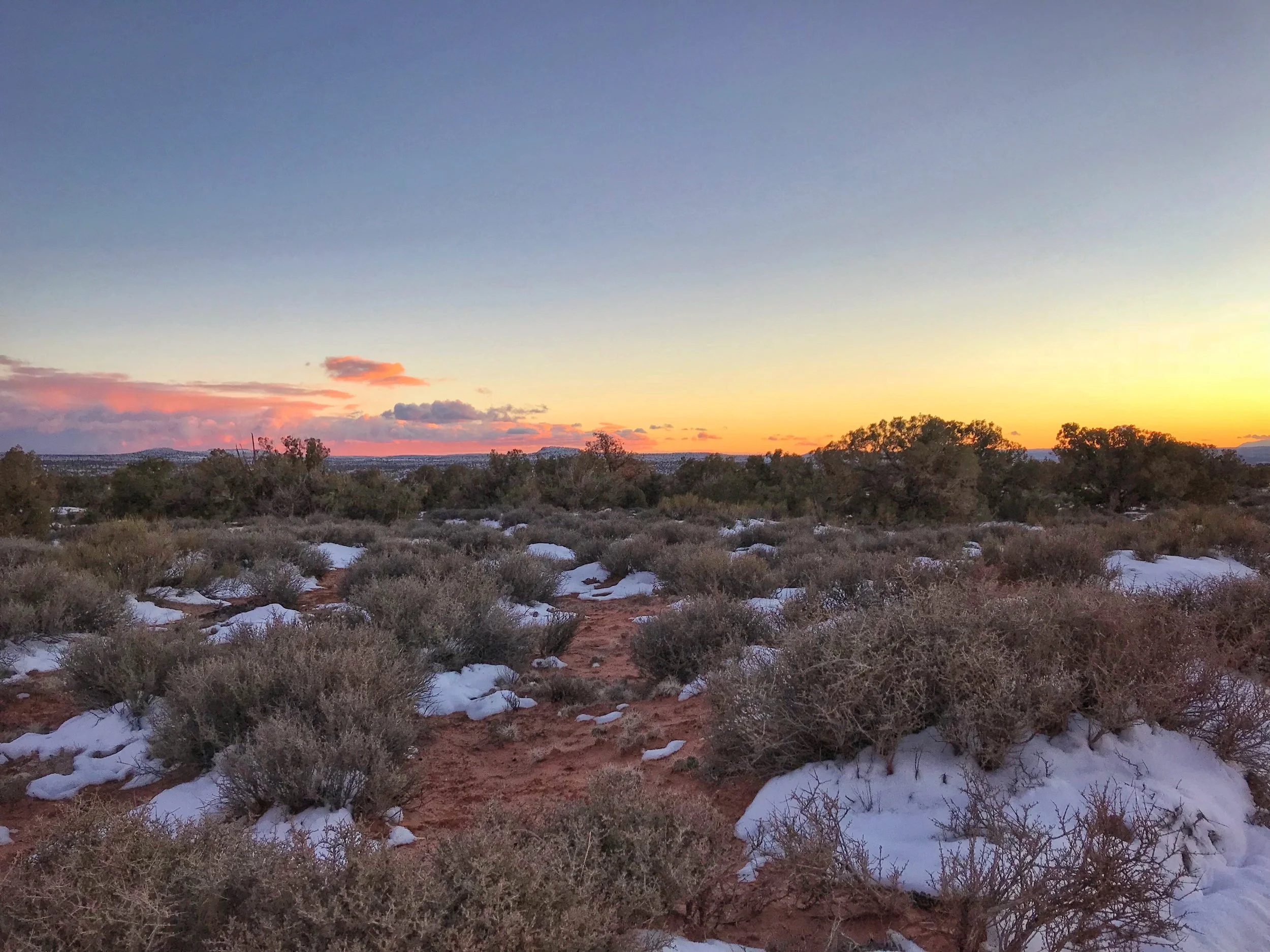
There are many amazing free campsites right outside Canyonlands. Don’t waste your money on a paid campground! We found an absolutely gorgeous spot along the Horsethief Trail, just beyond a dry campground that cost $16 per night! I went for a run on the quiet secluded road as the sunset. If you’re arriving in winter you’re definitely going to want to watch for mud in certain places though.
An amazing free campsite right outside Canyonlands in Utah.

We saw the most incredible sunset from Horsethief Trail right outside Canyonlands.
This road was so lovely and had so many campsites, we have no idea why someone would pay for the nearby campground.
Posts Also Tagged:
Arches, BLM Land, Buck Canyon, Canyonlands National Park, Canyons, Colorado River, Free Camping, Geology, Grand View Point, Green River, Hiking, History, Horseshoe Canyon, Island in the Sky, Mesa Arch, Moab, Mountains, National Parks, Natural Bridges, Photography, Public Land, Shafer Trail, Sunrises, The Maze, The Needles, Trails, Travel, Upheaval Dome, Utah, Vanlife, Whale Rock, White Rim, White Rim Road, Winter Travel
Have you been to Canyonlands National Park? What are your favorite spots? Let us know in the comments below.