How to Enjoy Bryce Canyon National Park in Winter
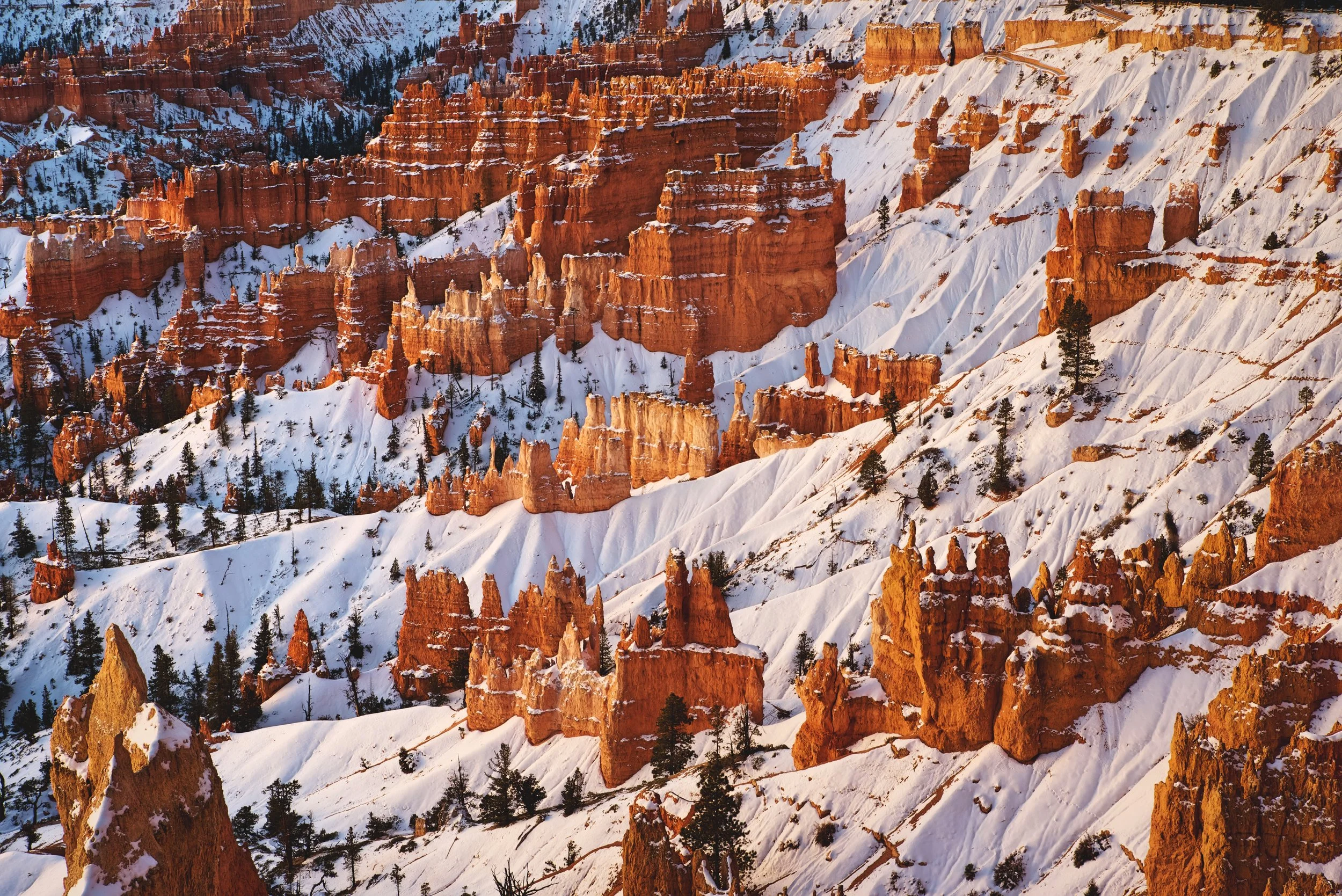
We visited Bryce Canyon National Park while we were traveling through Utah in December. It’s a unique and beautiful national park, and winter weather really adds to the park’s natural beauty. In reality, Bryce Canyon is not exactly a canyon. It’s actually the eroded edge of a plateau. A series of bowls and amphitheaters along the edge are filled with otherworldly spires, towers, and turrets called hoodoos. In fact, Bryce Canyon has the highest concentration of hoodoos anywhere on Earth.
Most of Bryce Canyon National Park’s 2 million annual visitors tour the park between March and October, but winter is a magical time in the park. The snow provides a stunning contrast to the red and pink rock of the hoodoos and accentuate the details in the stone. Our opinion is that chilly winter weather is much nicer that summer heat in the desert.
If you’re visiting in winter you should be prepared for cold weather, so bring lots of layers of clothing. (A warm but lightweight jacket like a nano-puff is a great option.) The rim of Bryce Canyon is at 8,000-9,000 feet, so it’s often colder than nearby Zion National Park. When we visited in December it was in the single digits at night, and it would get up into the 40s during the day. You might encounter muddy, snowy, and icy conditions on the trails, so hiking boots and additional traction devices like “Yak-Tracks” are recommended by the National Park Service. Some roads and trails in the park are closed throughout the winter. Check out this NPS guide to visiting Bryce Canyon in winter.

We noticed this cute little snowman sitting on the ledge of Agua Canyon. Winter is a wonderful time to visit Bryce Canyon National Park.
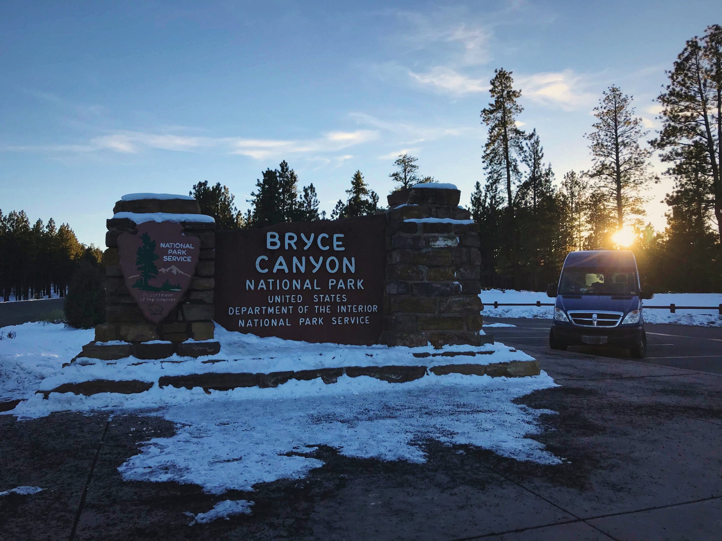
Our camper van parked by the entrance sign for Bryce Canyon National Park.
Start at the Visitor Center
Start your visit at the Bryce Canyon National Park Visitor Center to learn more about the natural and human history, geology, and wildlife of the park. You can find out trail conditions and get recommendations for your visit from helpful rangers and volunteers.
Drive Bryce Canyon Road
Bryce Amphitheater is the most famous and visited part of Bryce Canyon, and many visitors never go beyond this popular section which is only the first three miles of the park! The Bryce Canyon Road begins at the park’s only entrance at the north end of the park. It extends 18-miles south into the park, and the entire road is plowed in winter so that you can visit all the marvelous viewpoints along the road. Chilly or icy winter conditions might prevent you from doing long hikes in Bryce Canyon, but you can always jump in and out of your warm car to see the beautiful rocks of Bryce Canyon. Driving the road and stopping briefly at each viewpoint can easily be done in one day’s time.

Cold or icy conditions might limit your hiking in Bryce, but the viewpoints along Bryce Canyon are a great option instead.

The Bryce Canyon Road follows the rim of the canyon, pictured here.
Rainbow Point
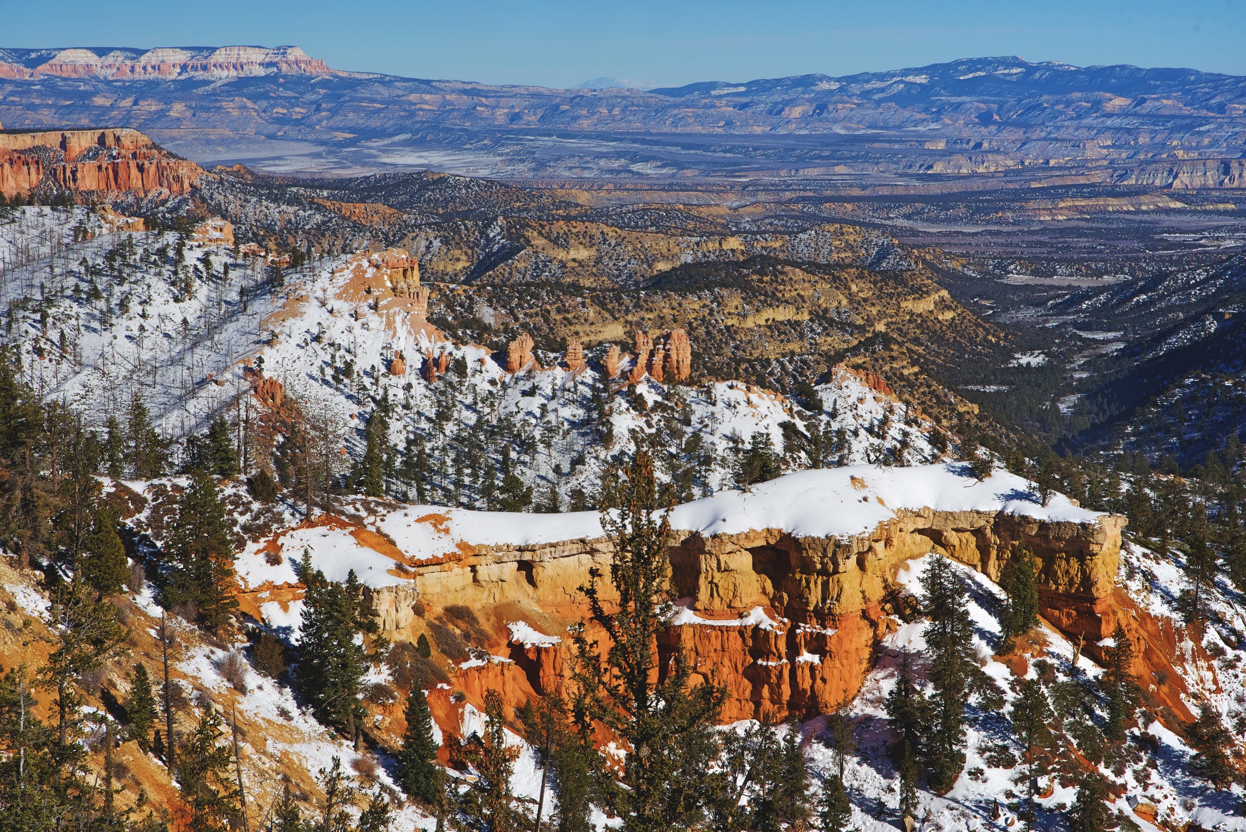
Begin your trip on Bryce Canyon Road by driving all the way to the south end of the Bryce Canyon Scenic Drive to the final viewpoints, Rainbow Point. This way, all the viewpoints will be on your right side. From Rainbow Point, you can look northward and survey the entire rim of Bryce Canyon from the highest point in the park at 9100 feet. Bryce Canyon is the top step of a massive geological formation called the “Grand Staircase.” Bryce Canyon is part of the Pink Cliffs layer of the Grand Staircase. In the distance you can see the various steps: Gray Cliffs, White Cliffs, Vermilion Cliffs, Chocolate Cliffs, and even the bottom step, which is the North Rim of the Grand Canyon.
Rainbow Point overlooks a large area interspersed with red and white hoodoos. The whole park was covered with snow during our visit, which provided a great contrast to the absurd shapes hoodoos. Plus the valley below the hoodoos is carpeted with evergreens that were also frosted with snow. There are a number of hiking trails that begin at Rainbow Point, but unfortunately due to the Riggs and Lonely fires, all the trails in the area were closed when we were in Bryce Canyon National Park.

Witness the eroded pink cliffs from the overlook at Rainbow Point.

From Rainbow Point you can also look north upon the rest of the park, which follows the rim of the plateau.

On the rim of Bryce Canyon, you are standing on the top step of a huge geological formation called the Grand Staircase.
Black Birch Canyon
A little further up the road, be sure to stop at Black Birch Canyon viewpoint. From the overlook, you look back toward Rainbow point over a big area of hoodoos at the steep canyon edge. Below, spruce and fir sprout up between the red walls of hoodoos. At Black Birch Canyon the view is a little less sweeping than at Rainbow, and you can get a little more up close and personal with the hoodoos. These hoodoos are quite humble in comparison to those at Bryce Amphitheater.

Black Birch Canyon offers a much closer view of the red cliffs of Bryce Canyon.

Black Birch Canyon is probably a view you can skip, if you don’t have much time in Bryce Canyon.
Agua Canyon
At the Agua Canyon viewpoint, the first thing we noticed was a massive raven sitting on the fence. He hopped right up to us, likely because I was eating an apple and he wanted a bite of it. Unfortunately he probably had been conditioned in this behavior by visitors who had fed the ravens in the past. You can spot these intelligent blue-black birds all over Bryce Canyon. Besides ravens, there’s a good chance you’ll see Steller’s Jays many places throughout the park as well.

Agua Canyon is well worth the stop if you’re driving along the Bryce Canyon Rim Road.

This big raven hopped right up to me, likely because I was eating an apple. He realized pretty quick that I wasn’t going to give him any though and lost interest in us.

If you get an opportunity to look at a raven’s feathers close up, they are a very shiny bluish-black color.
After the raven got bored of us and hopped away, we actually started to admire the stunning view from Agua Canyon Overlook. There are two main hoodoos that dominate the view at Agua Canyon. A tall rectangular hoodoo is somewhat inexplicably called “The Hunter.” A smaller hoodoo to the left is know as “The Rabbit” or “The Backpacker.”

This rectangular hoodoo with a red bottom and white top was named “The Hunter.”

This smaller hoodoo is called “The Rabbit.” From another perspective, it does look a rabbit. In the distance you can see Navajo Mountain as a blue lump on the horizon.
When Bryce Canyon was first designated as a national park, many of the prominent hoodoos in the park were named. Over the years a lot of the hoodoos have eroded or fallen so that they bear no resemblance to their namesakes. The park service, for this reason, has given up the practice of naming these fragile stone forms.
Natural Bridge
Six miles north of Rainbow Point is Natural Bridge. Natural Bridge was one of our favorite stops along the Bryce Canyon road. The bridge is a square shape with a perfectly circular opening underneath the stone of the arch. Natural Bridge reminded us of a castle or a cathedral because of it’s rugged top with the symmetrical arch below. The vibrant stone was highlighted by a layer of snow atop Natural Bridge. Below you, you can see a deep green ponderosa forest on the valley’s floor.
Natural Bridge is actually kind of a misnomer. Natural Bridge is technically an arch rather than a bridge, because it was formed by gradual weathering rather than a fast moving stream running beneath it.

Farview Point and Piracy Point
Continuing down the road, we stopped at Farview Point. Farview Point is a very fair view, and a far one as well. This is another place where you can witness the vast scale of the Grand Staircase. Because of the high air quality of Bryce Canyon National Park, you can see well into the distance to see the descending steps of the Grand Staircase. Closest is the Aquarius Plateau (Pink Cliffs) which is what you are standing on at Bryce Canyon National Park. Directly below, you can see the Kaiparowits Plateau or the Grey Cliffs. On the horizon, you can see the colorfully named Molly's Nipple of the White Cliffs formation. If the air quality is especially good you might see as far as 160 miles. You could even spot the Kaibab Plateau of North Rim of the Grand Canyon.
From Farview Point you get a panoramic view of the landscape of Bryce Canyon National Park and well beyond its boundaries as well. On the horizon in this photo, you can see the mountain called Molly’s Nipple.
There are not very many hoodoos visible from Farview point, but the distance of the panoramic vista definitely makes this a worthwhile stop along the Bryce Canyon Scenic Drive. In the foreground close to the point there is a fin that is capped with an erosion-resistant rock. This cap has prevented this fin from being transformed into hoodoos by the erosive force of water.

The view might be vast, but there’s also beauty to be found in the small details at every viewpoint.

We thought this scraggly old tree really added to the view at Piracy Point. Bryce Canyon is also home to some ancient (though relatively young for the species) bristlecone pines.
From Farview Point you can walk a short way to Piracy Point, which looks north up the canyon’s rim. The overlook got its colorful name because there are two buttes that supposedly look like battling sailing ships. With almost all the named formations in the park, it really requires a creative imagination to see the shapes their names evoke.

The Pink Cliffs of the Aquarius Plateau are what the hoodoos of Bryce Canyon are carved from.
Swamp Canyon
Swamp Canyon is a more intimate view than the view at Farview and Piracy Point. At this viewpoint you can see Mud and Noon Buttes. Swamp Canyon has two small creeks and a spring that run into the canyon, allowing more lush vegetation to grow in this area. In winter it’s hard to see the willow and grasses that grow here, because they are largely covered by snow.
From the Swamp Canyon overlook, you can hike the 4.3 mile Swamp Canyon loop or you can connect to the Under-the-Rim trail and some backcountry campsites as well. If you’re short on time, this is a viewpoint that you can probably skip without missing out on too much.

Swamp Canyon is a more lush area of the park, because it has more water sources.

Driving the Bryce Canyon Road is a nice way to spend a chilly afternoon.

Two buttes enclose the view at Swamp Canyon Overlook.
Bryce Point
Bryce Point is at the end of a two-mile spur road from Bryce Canyon Scenic Drive. If you’re driving the Bryce Canyon road from south to north, this is the first place you’ll get a view of the park’s classic areas of hoodoos—Bryce Amphitheater. Bryce Point is truly one of the most amazing views in the park. Because of the very thick ice, the park service had closed the viewing platform, but you can get almost the same view by walking a little ways out along the rim. Since it’s on a spit of land that extends into the canyon, from Bryce Point, you look back toward the magnificent pink walls windows and hoodoos of Bryce Amphitheater.

Ian looks out over the majestic Bryce Canyon at Bryce Point.
In late afternoon, Bryce Amphitheater is cast in a golden light, and from your perch high above the canyon you’ll observe a chaotic world of sandstone and shadow. Bryce Canyon is named after the Mormon settler Ebenezer Bryce, who really could have cared less about the scenic area he chose to farm and ranch. There is little record of his opinions of the landscape aside from his statement that, "It's a hell of a place to lose a cow." Looking down into the maze of hoodoos from Bryce Point, you can really see what he meant.

The exposed roots of this tree reveal just how quickly Bryce Canyon is eroding.

The Grottos at Bryce Point are a series of natural arches along one of the cliffs.
If you look closer at the are hoodoos below you can see an area called the Grottos. The grottos are “near arches” carved by erosion into the upper softer White Member of the Pink Cliffs. Some day these alcoves will become windows or arches. Eventually their tops will become too unstable and break away.
Northwest from Bryce Point, the “Wall of Windows” extends into the canyon. The formation is a narrow arm of stone that has a series of natural windows along its length. In the near geologic future, this wall will become a row of rock spires and hoodoos.

The Wall of Windows, which can be viewed from Bryce Point, will in the near future become the “Wall of Hoodoos.”
Inspiration Point
Inspiration Point provides another great view of the Bryce Amphitheater. There are three different viewing platforms, but they more or less look out at the same view. From Inspiration Point, it’s only a 0.7 mile walk along the Rim Trail to reach Sunset Point, and Sunrise point is only a half mile further on the trail. If you only have a limited amount of time for hiking though, we’d highly recommend one of the trails that leads into the canyon.

Ian takes a moment to take in Inspiration Point from the upper viewing deck.

You can walk between Bryce, Inspiration, Sunrise, and Sunset Points.
From Inspiration Point, you look over what is called “The Silent City.”—it’s a series of uniform series of hoodoos, which calls to mind an eerie, otherworldly cityscape. The hoodoos are a symmetrically layered in orange, white, pink, and red hues. The hoodoos and fins are extremely densely packed. A human would be a tiny speck in this maze of limestone and shadow.

Bryce Canyon was covered in a beautiful sparkly layer of snow when we were visiting in mid-December.

The “Silent City” from Bryce Point.
Sunset Point
Sunset Point is another popular overlook of Bryce Amphitheater. In late afternoon light sunset point is a rainbow of hues, from the White Member of the Claron Formation to the Pink Cliffs below. Orange, red, and golden layered minarets and towers sprout from the canyon below. You might even see purple from manganese deposits. Although the evening light does cast a golden glow upon the rock of Sunset Point, Bryce Canyon opens to the east, so the sun sets behind the canyon. Bryce Point which faces westward is probably the better spot if you’d like to watch the sunset while you’re at Bryce.

Snow on the hoodoos of Bryce Amphitheater near Sunset Point.
The Navajo Loop descends from Sunset Point. This trail leads to the famous Wall Street slot canyon, where Douglas Firs grow in the narrow sliver of light of the canyon. Unfortunately in winter this iconic part of the trail is closed because of a high danger of rock falls due to ice wedging. When we were visiting in December, the Navajo Loop was actually closed in both directions because of super icy conditions.

A series of switchbacks leading down to the Navajo Loop.

Even though the Navajo Loop was mostly closed while we were there, we could still get down to these cool windows carved through the stone.
We were able able to descend about a quarter mile down the treacherously slippery Navajo Loop to some really cool windows in the stone that allow you to look out over other areas of hoodoos. Looking down on the trail, it’s a feat of engineering on its own—a series of tight switchbacks lead into the network of hoodoos and canyons below Sunset Point. If we get the chance to visit Bryce Canyon National Park in Summer, we will definitely hike the Navajo Loop.

We liked these little doorways that frame the view in many places at Bryce Canyon National Park.

The view from Sunset Point is lovely, and the perfect place for a photo.

If you’re looking for an easier walk, you can walk the accessible trail along the rim between Inspiration Point, Sunset Point, and Sunrise Point.
Wake up Early to Watch the Sunrise at Sunrise Point
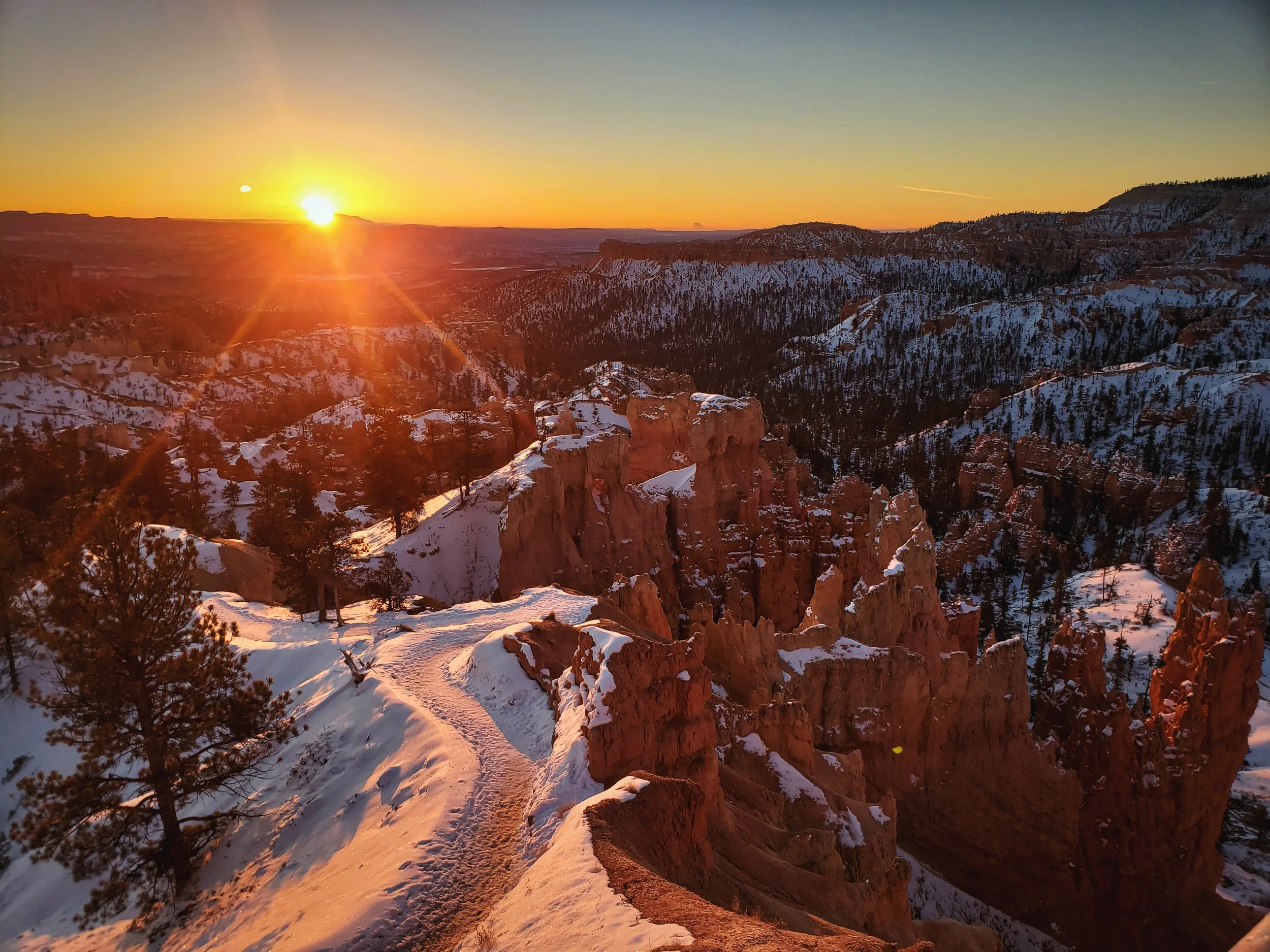
Another great thing about visiting Bryce Canyon National Park in winter is that the sun rises later in the day, so you don’t have to get up insanely early in order to see the sunrise! We woke up at 5:45 am, made coffee, drove into the park from our free campsite outside the park, and still made it to Sunrise Point well before the sunrise at 7:30. The best moments of the sunrise are often before the sun rises above the horizon, so try to arrive at least 20 minutes before the sun actually rises.

We really enjoy the time before sunrise as much as we like the actual sunrise.

It was -3 degrees with windchill when we watched the sunrise at Sunrise Point in Bryce Canyon National Park.
The downside of watching the sunrise in winter is that dawn is the coldest time of day. It was 7 degrees when we were watching the sunset, but with wind chill it was -3 degrees! The upside of really cold dawn temperatures is that you’ll likely have Sunrise Point Nearly to yourself. We were the only ones there, except for a few other tourists who trickled in a few minutes before the sun rose above the horizon.

The snow is turned a rosy color when the sun rises in winter.

There was a cloud inversion across the valley from us that began rolling forward as the sun warmed it.
When we arrived the sky was a deep turquoise gradient with a ruddy maroon streak on the horizon. Soon however, the sky lightened to a pale blue with an orange- yellow glow emerging from the horizon. A cloud inversion formed across the valley from us, and we watched its rolling progression out from behind and over the Sinking Ship formation. We could see it pushing across the valley like a pale pink flood.

This mist started to surround the Sinking Ship formation across the canyon from us.
Right before 7:30, the sun burst over the horizon. This is one of my favorite moments—when you can visibly see the Earth rolling toward the sun. Surrounding us in the valley, the hoodoos had turned a warm golden color as the sun’s early light was projected upon them. If you’re lucky enough to visit when there is snow on the canyon walls, you’ll find that the snow also turns a rosy color as the sun rises.
The Queen’s Garden Trail descends from Sunrise Point.

We almost had Sunrise Point entirely to ourselves because it was so cold while we were visiting.
The cloud inversion turned a lavender-pink color, and as the sun’s rays started to heat the vapors, the clouds really started churning and moving across the valley. With the sun above the horizon we were also able to appreciate that trees and manzanitas were covered with a sparkling hoar frost. The warm day time temperatures and cold nighttime temperatures had formed a layer of shimmering ice crystals on top of the snow as well.

It was only after sunrise that we noticed that all the trees were covered with this beautiful frost.

The frost even made scrubby bushes like these look gorgeous at sunrise.
Hike the Fairyland Loop
If you’re looking to delve a little deeper into Bryce Canyon in the winter, the 8-mile Fairyland Loop is the way to go. The Fairyland Trail is considered one one of the quintessential day hikes in Bryce Canyon National Park. We liked this day hike so much that we wrote an entire blog post about it. Check it out here! The trail begins on the rim of the canyon and descends into the depth of the hoodoos. Fairyland Loop lives up to his name, meandering through a landscape of quirky and bulbous stone towers and castles. In winter, the snow only makes the route more magical.

With the right gear, you can easily hike the Fairyland Loop in winter.

The Fairyland Trail begins on the rim of Bryce Canyon and then descends deep into the otherworldly hoodoos.
In winter, the road to Fairyland Point, where the trail typically starts, is closed. Instead, you can start at Sunrise Point, which adds about a mile to the loop. In winter you should be prepared to encounter ice, snow, and very stick mud along the trail. Over the course of the trail you climb about 1100 feet, and the last two miles of the trail are almost entirely uphill. In cold weather, you should wear layers so that you can take some layers off while you’re exerting yourself on the climb out the canyon.

We thought these eroded layered slopes were really lovely and unique.

The hoodoos of Fairyland have a different look than those in Bryce Amphitheater.
the ChinA Wall and Tower Bridge
There are two fun named formations along the Fairyland Loop: The China Wall and Tower Bridge. When you’re hiking on the Fairyland Loop Trail, a short 200 yard spur trail takes you to the Tower Bridge. It’s a wall with two pointed spires with a natural bridge between. The rock formation looks like the Tower Bridge in London. Further along the trail, you can see the China Wall as well, which is a long wall with many small openings along its length.

This formation does kind of look like the Tower Bridge from an angled perspective.

This wall of windows will one day be a long row of hoodoos in a line.
Hike the Queen’s Garden Trail and Pay Tribute to Queen Victoria
The Queen’s Garden trail descends into Bryce Amphitheater near Sunrise Point. It’s fairly steep, but it’s considered the easiest way to get down into the canyon. The trail is built into the canyon wall with brick switchbacks. In a few places there are tunnels or doorways carved through the sandstone fins that allow you to pass through them. The hoodoos in this part of the canyon are a very brilliant orange color, which is only accentuated further by the freshly fallen snow resting atop them.

The Queen’s Garden Trail is considered the easiest trail descending into the hoodoos of Bryce Canyon.

Switchbacks built from bricks on the Queen’s Garden Trail.

The Queen’s Garden Trail is a great place for photography.
We only went down the trail .9 miles to the Queen Victoria formation. Wall Street, a famous part of the Queen’s Garden-Navajo Loop Trail is closed in winter, so we could not connect this trail the Navajo Loop for a longer hike. The Queen’s Garden Trail is the most popular trail in the park, but with good reason—it’s incredibly beautiful. However since we were visiting in winter, we were able to avoid a lot of the crowds would typically be found on this trail in summer.

We really enjoyed this doorway which has been carved to allow you to walk through a fin.

This is Queen Victoria at the end of the Queen’s Garden Trail.

My boots just decided to give up on the Queen’s Garden Trail. That’s okay because I’d almost always rather wear a pair of sturdy trail runners.
We ended our hike at the Queen Victoria, a tower that kind of looks like Queen Victoria in a robe and crown astride a backwards horse. You kind of have to squint to see it. She’s surrounded by the “garden,” a semi-circular ridge of thin, eroded pinnacles above the trail. Overall, the Queen’s Garden Trail is a really great one. If you only have time for one short hike in Bryce Canyon National Park, make it this one.
My boots completely fell apart while we were on the Queen’s Garden Trail in Bryce Canyon National Park.
Parts of this trail were extremely icy when we were visiting and we were wishing we had some sort of traction devices for our boots, especially as we were going down the icy hills. During the course of the hike, the soles of my boots almost totally separated from the upper. That added a hilarious twist to the hike as we were slipping our way back to the van, and the heels of my boots were slapping against the ground. I would definitely recommend wearing a more reliable pair of shoes for hiking in Bryce Canyon in winter.
Free camping near Bryce Canyon National Park:
Our first night at Bryce Canyon, we camped right outside the park entrance at a small parking lot for the nearby Great Western OHV Trail system. Technically the camping spots are off the main road in the woods and not the paved parking lot. The snow covering the forest service road was really deep though so we didn’t want to risk getting stuck out in the woods when the temperature was only in the teens. Even though we were right by the road, nobody bothered us while we slept here and the road noise was very minimal at night. Plus since this spot was literally one minute from the park’s entrance, it made it easy to get up to watch the sunset early the next morning.

We encountered some of the coldest temperatures we’ve ever slept in the van in while in Bryce. (This thermometer is nice because it shows us the temperature in our van and outdoors.)

Both of our campsites outside of Bryce are great free sites, but we couldn’t get very far down the roads because of snow!
On our second night in Bryce Canyon, we camped on some BLM land about 15 minutes from Bryce Canyon National Park. The site was along Tom’s Best Spring Road. There are numerous dispersed camping sites along this road, and it’s a beautiful open area interspersed with juniper trees. Again the entire area was covered with deep snow, but fortunately for us the snow was super dry since it was so cold and the ground was frozen. Other people had already made tracks on the road, and we were able to make it to a campsite just a little way down the road, without having to worry about getting stuck in the snow.
Posts Also Tagged:
Agua Canyon, Arches, Black Birch Canyon, BLM Land, Bryce Amphitheater, Bryce Canyon National Park, Bryce Point, Canyons, FairyLand, Farview Point, Free Camping, Geology, Hiking, History, Inspiration Point, Mountains, National Parks, Natural Bridges, Queen’s Garden, Photography, Piracy Point, Public Land, Rainbow Point, Road Trip, Sunrise Point, Sunrises, Sunset Point, Sunsets, Swamp Canyon, Trails, Travel, Utah, Vanlife, Wildfires, Wildlife, Winter Travel
Have you visited Bryce Canyon in winter? What were your favorite parts about visiting in winter? Leave a comment to share your experience with others.