Day 14- Lake Superior Circle Tour: The Soo to Hiawatha National Forest

Day 14
Before leaving Canada on our Lake Superior Bike Tour, we had to get some Tim Horton’s coffee and donuts. We ate this sweet breakfast in the motel room that we had rented the previous night.
As we were rolling our bikes out of our room in the morning, I noticed that I had a flat tire on my bike. This was just one repair in a series of recent bicycle-based mishaps. We changed the tire in the parking lot, discovering that a small shred of metal left behind after the rim had been machined has caused it. It was a wonder it had already made it three-quarters of the way around Lake Superior.

We started our day with this Canadian delicacy.

We found this shred of metal inside the rim of my bike wheel.

It’s amazing that it did not give me a flat tire sooner.
After leaving the hotel, we navigated through Sault Ste. Marie, Ontario, making our way through neighborhoods of older single family homes and across railroad tracks. There is a certain aesthetic in cities, such as Superior, Ashland, and Munising, of the Upper Peninsula and Northern Wisconsin. Despite being across the Canadian Border, Sault Ste. Marie feels just the same. Mostly friendly, but a little bit tired too.

It’s always a good day when you start off first thing with a flat tire.

Any long bike tour is going to have you changing a fair number of flats.
Soon we reached the Sault Ste. Marie International Bridge. This bridge crosses the famous Soo Locks on the St. Mary’s River, which are a critical part of the St. Lawrence Seaway. Freighters, stretching up to 1000 feet in length, are lifted and lowered over the 21 foot difference between Lake Superior and Lake Huron. For this reason, locks are known as the “lynchpin of the Great Lakes.”

Crossing the Sault International Bridge into the US was pretty easy even though there is no pedestrian path. The traffic is very slow.
Actually getting onto The Sault Bridge was kind of confusing, and there’s no pedestrian path on the bridge. Fortunately, the speed limit is only 50km per hour which is about 30mph. Because cars are approaching customs, it also seemed that car’s were behaving quite well. We didn’t think the bridge was scary to cross at all.
We made it almost all the way across the bridge before we hit the line of cars waiting to go through customs to get back into the US. Even though it was a Sunday morning, it wasn’t too long, and we decided to just wait it out. If it had been much longer, we probably would have cut ahead a little bit, because it was incredibly hot and exposed on the surface of the bridge.
Even though this customs station was much larger and more “official” feeling than the small customs station near Grand Portage in Minnesota, it was simple to go through. They didn’t even ask us any questions, and the process was quick.
After reentering the US, we ate lunch at the Michigan Welcome Center just across the border. Ian exchanged our Canadian money at the Holiday Station that was just across the road. We also talked to another tourist who told us the road through Pictured Rocks National Lakeshore was unpaved, and we decided to reroute. Unfortunately, that tourist was wrong, and we missed out on a beautiful stretch or road—something we would later regret while biking on a treacherous alternative road.

Sault Ste. Marie Michigan is a interesting city to explore by bike.
Feeling good, but about the same, to be back in our country of origin, we biked into downtown Sault Ste. Marie, Michigan. We passed the Soo Locks, and got a stamp on our Lake Superior Circle Tour passport from a very grumpy woman at Soo Locks Boat Tours. We checked out the interesting lock buildings and the touristy downtown of Sault Ste. Marie. There was even a rendezvous going on at the City Hall (A rendezvous is a historical reenactments of the fur trading period, and they are a common summertime festival found throughout the upper Midwest region.)

The Rendezvous on the Sault was taking place at City Hall.

The rendezvous reenacts the region’s fur trading period.
We headed out of town on a paved bike path, eventually getting onto 4th Avenue and Oak Street. We turned left onto 20th Street and headed south. These were quiet town roads. While they didn’t have much in the way of shoulders, there were very few cars and farmhouses with kids and dogs that didn’t chase, square hay bales in the hot humid summer air. It was quite a change from the Trans-Canada Highway where we were always on edge because of the busy traffic.

These quiet country roads were a relief after spending so much time on the Trans-Canada.

The land outside Sault Ste. Marie is agricultural, but we entered the National Forest soon after.
From these roads, we headed west on 5 Mile and then 6 Mile Road. This road eventually becomes Lakeshore Drive, which follows the lake after you go through Brimley, a small settlement along the Lake. We really loved this part of the tour with its rolling fields and snug farmhouses.

The sky on Day 14 of our Lake Superior Circle Tour was like something out of a painting.

Even the shoulder of this county road was wider than the shoulder of the Trans-Canada Highway.
We soon entered the Hiawatha National Forest. While this is not one of the more famous national forests, it certainly is beautiful. We discovered the cutest little miniature lighthouse in Bay Mills. It was on the shore of a small body of water called the South Pond. A few minutes later we came upon the lighthouse which we realized later was a replica—of the Point Iroquois Lighthouse. If you want to see the funniest review of a roadside attraction, check out the reviews of this little light house on Google Maps.
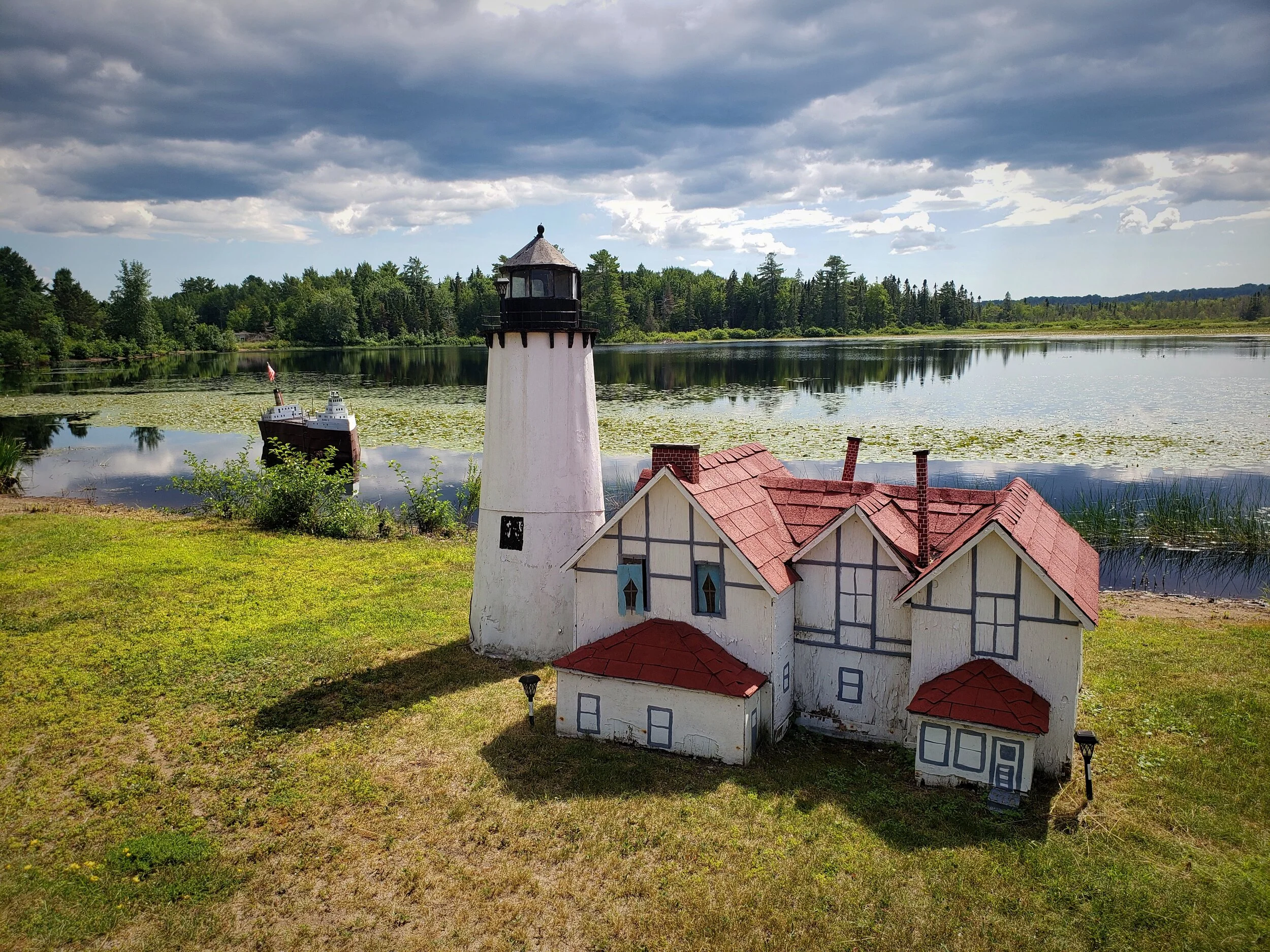
This is the cutest little roadside attractions in the Upper Peninsula.

We soon realized this is a replica of a much bigger Point Iroquois Lighthouse.

In the background you can see the little freighter that is being kept safe by this little lighthouse.
Soon we reached this little lighthouse’s much larger twin. At the Point Iroquois Lighthouse, we locked up our bikes and we wandered around the historic museums that recounted all sorts of maritime tales. The original Fresnel lens is on display in the museum, along with a number of vintage navigational devices. This light could project light nearly 16 miles, but eventually it was replaced by an automatic light in Gros Cap, Ontario, after 107 years of service.

Ian was amazed by the original glass fresnel light.
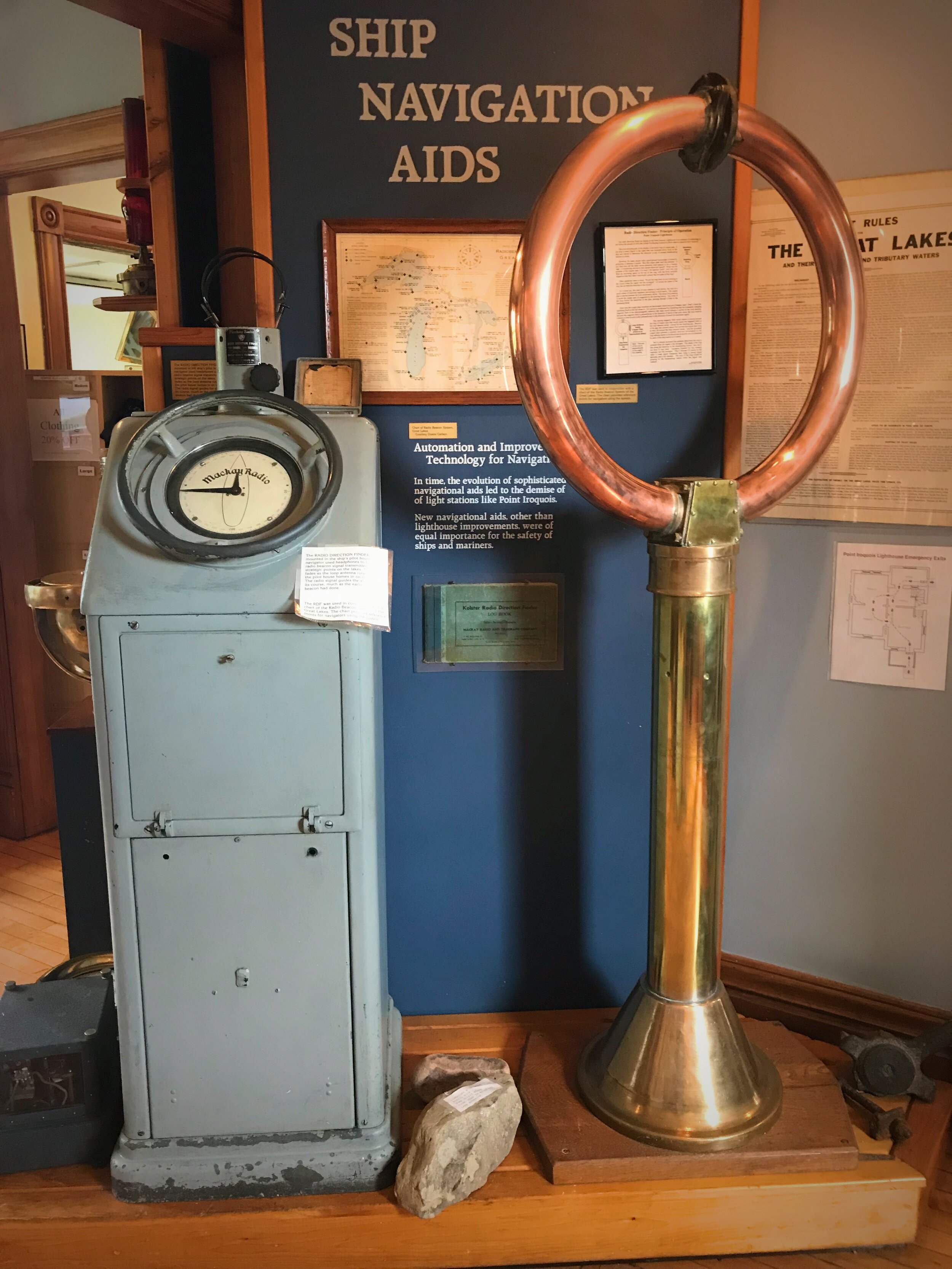
The museum has a number of fun navigational devices.
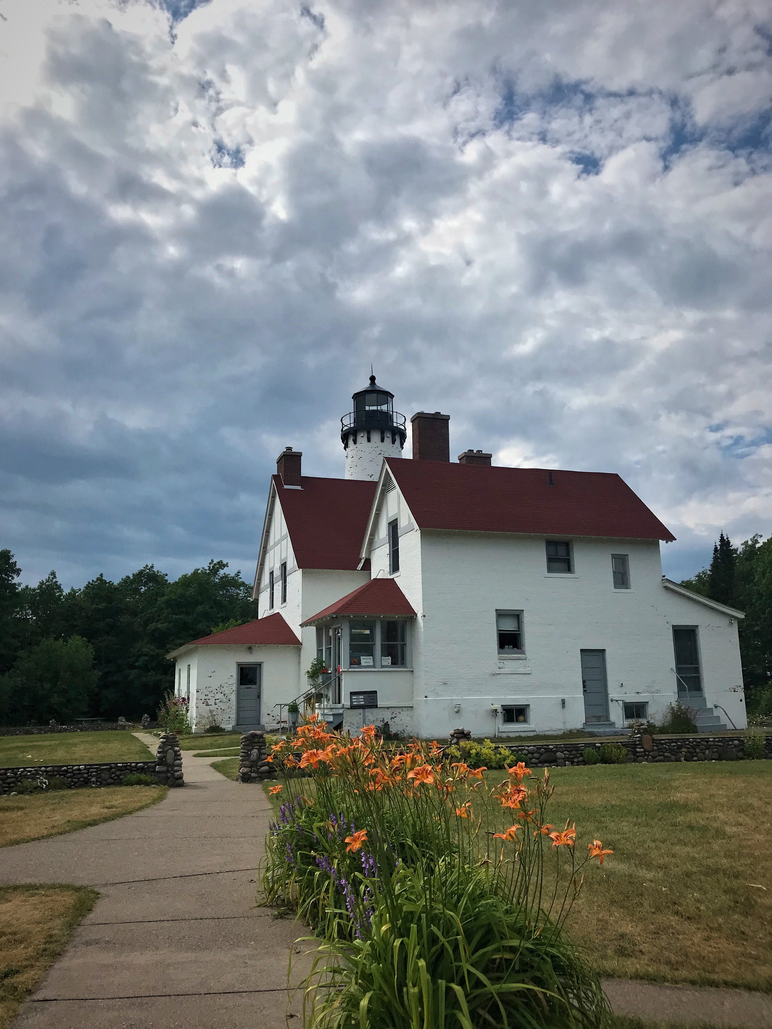
The lightkeeper’s residence at Point Iroquois.
We explored the 1950s lightkeepers’ homes. The quaint red and white brick house reminds you of what it would have been like to live here as a lighthouse keeper, when this was a major shipping channel. Whitefish bay is the entrance to Lake Superior for freighters, and a treacherous passage too. Sailors had to navigate through a narrow passage between the shoals and sandbars of Point Iroquois without steering too close to rocky reefs on the Canadian side.

The lightkeeper’s resident is set up as it would have been in the middle of the 20th century.

A small school was also operated at the lighthouse.

Today “lighthouse keepers” take care of the lighthouse, give tours, and work in the gift shop.
Finally we climbed the ornate spiral staircase to the top of the 65-foot tower to the top of the lighthouse. At the top is a beautiful view of this part of Lake Superior, which is pale and shallow. From here you can see Canada and frequently a freight liner creeping it’s way into the St. Mary’s River toward the Soo Locks.

The original fresnel lens from the lighthouse is beautiful.

The spiral staircase leads to the top of the lighthouse tower.

Climbing to the top of the tower is fun, as long as your legs aren’t too sore.
We finished our tour of Point Iroquois with a walk along the boardwalk, were we even picked some blueberries. This area of the lakeshore has dry and sandy soil with tall pine trees—precisely the type of microbiome that blueberries thrive in. Most of them weren’t quite ripe enough to pick yet.
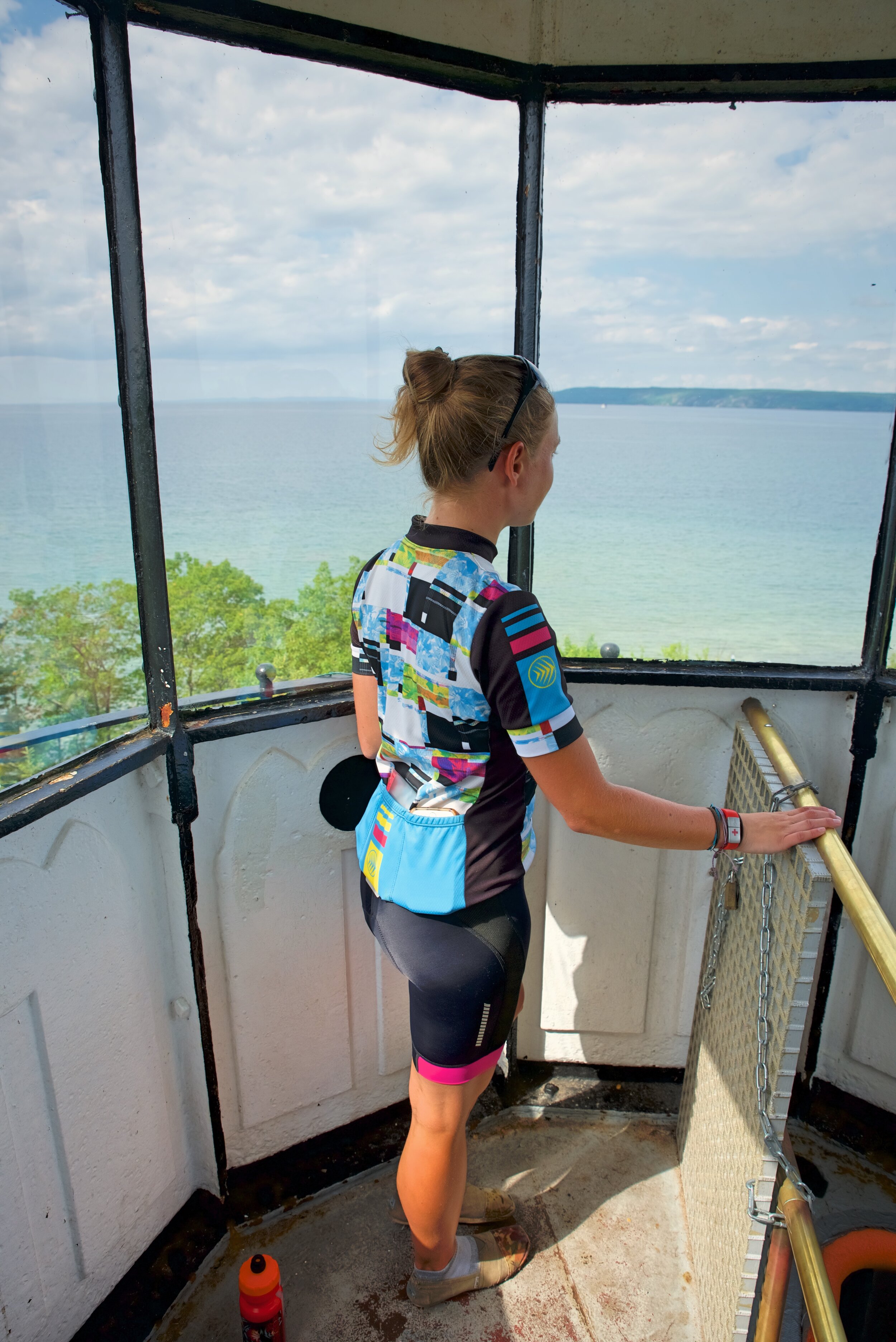
From the top of the Point Iroquois Lighthouse you can see Canada.

The Point Iroquois lighthouse is a quaint red and white.

It was interesting to be able to see the area of Canada we had just come from.

It’s interesting to think about what it would be like to live here.

This part of Lake Superior is shallow and sandy.
Our plan for this night was to simply dispersed camp somewhere in the national forest. What we found while riding through the Hiawatha National Forest was that most of the land right along the road wasn’t national forest land, rather it was people’s private vacation homes. Many of the other areas on the lake side of the road were marked as “Day Use Only,” while on the other side of the road there was a steep bluff that would prevent anyone from camping on it. The small road we had planned to camp on turned out to be in the middle of a mosquito invested slough.
In the Hiawatha National Forest we climbed up and over several large hills as night quickly approached. We found a little rest area with beautiful Hop-Hornbeam trees that were in bloom. We had never seen these trees before and the flowers look just like a giant hop flower.

The land surrounding Point Iroquois is sand and blueberries proliferate.

Lighthouses are an important part of Lake Superior’s maritime history, and it’s a good stop for a Lake Superior Circle Tour.
Finally, right before we were about to leave the Hiawatha National Forest, we found a beach with picnic tables. We decided to cook dinner there. The lake was perfectly still and I decided to go for a swim. This section of Lake Superior is extremely shallow. In fact where we stopped was called “The Shallows.” Where the shore on the northside of the lake had been cold and rocky, by contrast, this portion of the southern shore was shallow and sandy. You could walk a quarter mile out and still only be around chest height, encountering sand bar after sand bar. The water near the shore was also filled with a thick algae or plant matter, but the swimming was still nice, simply because the water was so warm.

This area of the lake is called “The Shallows.” The water here is nice for swimming.

The Hop-Hornbeam trees were blooming when we were in the Hiawatha National Forest. The flowers look like hops.
We noticed that the North Country Trail was running along the shore from the beach, so we decided to walk down the trail to see if we could find a campsite. About a half mile up the shore we found a campsite under some big white pines, out of site of the road and out of the rain that had started to fall.

The sky over the lake was beautiful when we campled.

The North Country Trail pictured here runs from North Dakota to Vermont.
We weren’t necessarily sure we were supposed to be camping there, but it certainly wasn’t the first time on this tour that we had stealth camped. It certainly wasn’t the worst place that we stealth camped. We were sheltered by large white pines and were able to pitch our tent on some soft pine duff. We slept well listening to the waves and the rain roll into the shore.

The Point Iroquois Lighthouse has a weathered brick exterior that looks like it belongs in a trendy hipster neighborhood.

POSTS ALSO TAGGED:
AEROTECH DESIGNS, Bay Mills, BEACHES, BIKE ROUTES, BIKE SAFETY, BIKE TOUR PLANNING, BIKE TOURING, BIKING, BORDER CROSSINGS, Bridges, Brimley, CAMPING GEAR, CANADA, CITIES, COFFEE, CYCLING GEAR, FLAT TIRES, Forest Service Land, FREE CAMPING, FRUGAL TRAVEL, GREAT LAKES, Hiawatha National Forest, History, Lake Huron, LAKE SUPERIOR, LAKE SUPERIOR CIRCLE TOUR, Lighthouses, MICHIGAN, Museums, National Forests, North Country Trail, ONTARIO, Point Iroquois, PUBLIC LAND, Rendezvous, Roadside Attractions, SAULT STE. MARIE, Soo Locks, St. Mary’s River, Stealth camping, TENTS, Trails, TRAVEL, Trees, Upper Peninsula
Leave a comment below to share your experiences crossing the US-Canada by bike or any tips you have for the Lake Superior Circle Tour!